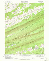
1969 Map of Enders
USGS Topo · Published 1972About this map
Peters Mountain and Third Mountain dominate this part of the Appalachian landscape, creating a series of parallel ridges and valleys that shaped local development through the late 1960s. The northern valleys are dotted with small agricultural and crossroads settlements like Enders and Enterline, where social life centered on institutions such as the Enders-Fisherville Sch and Bowerman Ch. To the south, the terrain remains largely forested within State Game Lands No 211, preserving the wilderness character through which the Appalachian Trail and Darlington Trail wind.
Find a feature on this map
56 named features on this map. Tap any name to fly to it.
Don’t see what you’re looking for? This feature index may not catch every label — zoom into the map to look around manually.
Map Details
Editions of this 1969 Enders Map
4 editions found
Other maps of this area

1892 · Lykens
USGS Topo · 1:62,500

1892 · Hummelstown
USGS Topo · 1:62,500

1892 · Harrisburg
USGS Topo · 1:62,500

1893 · Lykens
USGS Topo · 1:62,500

1893 · Millersburg
USGS Topo · 1:62,500

1899 · Harrisburg
USGS Topo · 1:62,500

1924 · Hummelstown
USGS Topo · 1:62,500

1924 · Harrisburg
USGS Topo · 1:62,500

1943 · Millersburg
USGS Topo · 1:62,500

1943 · Lykens
USGS Topo · 1:62,500
Featured Places
- Jackson Township, PA
- Jefferson Township, PA
- West Hanover Township, PA
- Rush Township, PA
- Middle Paxton Township, PA