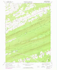
1969 Map of Enders
USGS Topo · Published 1977About this map
Peters Mountain and its parallel ridges dominate this landscape, illustrating the dramatic geography of central Pennsylvania. The map highlights a series of isolated settlements such as Enders, Enterline, and Carsonville nestled between the steep slopes of Dividing Ridge and Second Mountain. The valley floors are marked by evidence of early industry and community life, including Victoria Furnace and Ellendale Forge along Stony Creek, alongside numerous country churches like Bowerman Ch and St James Ch. A massive portion of the central terrain is dedicated to State Game Lands No 211, where the Appalachian Trail follows the ridge line of Peters Mountain. This survey also captures essential local infrastructure from the late 1960s, such as the Clark Creek Aqueduct, the Stony Mountain Lookout Tower, and the small Gusler Airport.
Find a feature on this map
51 named features on this map. Tap any name to fly to it.
Don’t see what you’re looking for? This feature index may not catch every label — zoom into the map to look around manually.
Map Details
Editions of this 1969 Enders Map
4 editions found
Other maps of this area

1892 · Lykens
USGS Topo · 1:62,500

1892 · Hummelstown
USGS Topo · 1:62,500

1892 · Harrisburg
USGS Topo · 1:62,500

1893 · Lykens
USGS Topo · 1:62,500

1893 · Millersburg
USGS Topo · 1:62,500

1899 · Harrisburg
USGS Topo · 1:62,500

1924 · Hummelstown
USGS Topo · 1:62,500

1924 · Harrisburg
USGS Topo · 1:62,500

1943 · Millersburg
USGS Topo · 1:62,500

1943 · Lykens
USGS Topo · 1:62,500
Featured Places
- Jackson Township, PA
- Jefferson Township, PA
- West Hanover Township, PA
- Rush Township, PA
- Middle Paxton Township, PA