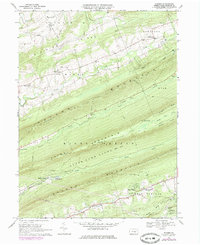
1969 Map of Enders
USGS Topo · Published 1984About this map
Peters Mountain and its neighbors dominate this landscape, forming a series of parallel ridges that dictated the settlement patterns of northern Dauphin County. In the valleys between these steep rises, communities like Enders and Carsonville established themselves along the waters of Powell Creek and Clark Creek. The presence of Victoria Furnace and Ellendale Forge reflects an era of local industry where the valley's resources were harnessed for iron production.
Find a feature on this map
55 named features on this map. Tap any name to fly to it.
Don’t see what you’re looking for? This feature index may not catch every label — zoom into the map to look around manually.
Map Details
Editions of this 1969 Enders Map
4 editions found
Other maps of this area

1892 · Lykens
USGS Topo · 1:62,500

1892 · Hummelstown
USGS Topo · 1:62,500

1892 · Harrisburg
USGS Topo · 1:62,500

1893 · Lykens
USGS Topo · 1:62,500

1893 · Millersburg
USGS Topo · 1:62,500

1899 · Harrisburg
USGS Topo · 1:62,500

1924 · Hummelstown
USGS Topo · 1:62,500

1924 · Harrisburg
USGS Topo · 1:62,500

1943 · Millersburg
USGS Topo · 1:62,500

1943 · Lykens
USGS Topo · 1:62,500
Featured Places
- Jackson Township, PA
- Jefferson Township, PA
- West Hanover Township, PA
- Rush Township, PA
- Middle Paxton Township, PA