2023 Map of Endicott
USGS Topo · Published 2023About this map
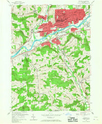
The Susquehanna River valley serves as the central artery for this industrial and residential corridor, where the urban reaches of Endicott and Endwell meet the northern slopes of the Appalachian Plateau. The landscape is defined by a dense network of suburban developments like Tioga Terrace and Crest View Heights that contrast with the steep, wooded rises of Grippen Hill and Pierce Hill. Along the riverbanks, the Norfolk Southern rail line and Tri-Cities Airport underscore the region's role as a transportation hub.
Find a feature on this map
238 named features on this map. Tap any name to fly to it.
Don’t see what you’re looking for? This feature index may not catch every label — zoom into the map to look around manually.
Map Details
Editions of this 2023 Endicott Map
This is the sole edition of this map. No revisions or reprints were ever made.
Historical Maps of Twin Orchard Through Time
4 maps found