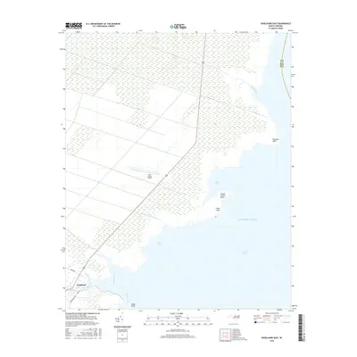
2016 Map of Engelhard East
USGS Topo · Published 2016About this map
Engelhard serves as the focal point of this coastal landscape, situated where the low-lying marshes of Hyde County meet the vast expanse of the Pamlico Sound. This 2016 survey illustrates a delicate environment of tidal creeks and marshes, with the Hyde County Airport positioned amidst the wetlands northeast of the main settlement. The complex hydrology is defined by numerous waterways including Kitty Creek, Far Creek, and Waupopin Creek, all draining toward the sound. The coastline is marked by distinctive features such as Juniper Swamp Point and Shad Point, which frame the opening of Otter Creek. Along the northern reaches, the Broad Creek estuary creates a significant break in the shoreline. The map reveals the intricate relationship between the land and the Atlantic Ocean, showing how roads like Swamp RD and Goshen Back RD navigate the saturated terrain to reach the water's edge at Berrys Bay.
Find a feature on this map
19 named features on this map. Tap any name to fly to it.
Don’t see what you’re looking for? This feature index may not catch every label — zoom into the map to look around manually.
Map Details
Editions of this 2016 Engelhard East Map
This is the sole edition of this map. No revisions or reprints were ever made.
Other maps of this area
1943 · Columbia
USGS Topo · 1:125,000
1943 · Roanoke Island
USGS Topo · 1:125,000
1951 · Middletown Anchorage
USGS Topo · 1:24,000
1951 · Middletown
USGS Topo · 1:24,000
1951 · Engelhard West
USGS Topo · 1:24,000
1951 · Long Shoal Point
USGS Topo · 1:24,000
1951 · Engelhard East
USGS Topo · 1:24,000
1953 · Engelhard NW
USGS Topo · 1:24,000
1953 · Fairfield NE
USGS Topo · 1:24,000
1953 · Engelhard NE
USGS Topo · 1:24,000