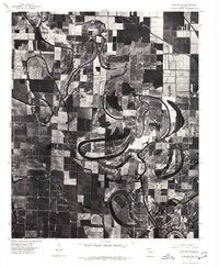
1975 Map of England SE
USGS Topo · Published 1977About this map
Crooked Creek snakes through a heavily cultivated landscape in this mid-1970s orthophotograph, its winding path and oxbow remnants revealing the natural hydrology of the Arkansas Delta. The area is defined by a geometric grid of agricultural fields, punctuated by small rural settlements like Humnoke and Allport. This specific type of imagery, an orthophotograph produced by the U.S. Geological Survey from aerial photography taken in late 1975, offers a photographic record of land use and drainage patterns that standard topographic maps might overlook. To the west, the settlement of Coy sits near the banks of Salt Bayou, while Seaton occupies a central position along the meandering creek. The map illustrates the transition of the local landscape as traditional watercourses were integrated into an intensive regional farming system.
Find a feature on this map
6 named features on this map. Tap any name to fly to it.
Don’t see what you’re looking for? This feature index may not catch every label — zoom into the map to look around manually.
Map Details
Editions of this 1975 England SE Map
This is the sole edition of this map. No revisions or reprints were ever made.
Other maps of this area

1935 · Altheimer
USGS Topo · 1:62,500

1937 · Stuttgart
USGS Topo · 1:62,500

1937 · England
USGS Topo · 1:48,000

1939 · Stuttgart
USGS Topo · 1:62,500

1941 · Goldman
USGS Topo · 1:62,500

1943 · England
USGS Topo · 1:62,500

1948 · Helena
USGS Topo · 1:250,000

1950 · Helena
USGS Topo · 1:250,000

1955 · Helena
USGS Topo · 1:250,000

1959 · Helena
USGS Topo · 1:250,000