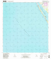
1994 Map of Englewood NW
USGS Topo · Published 1998About this map
Manasota Key forms a slender protective barrier between the open Gulf of Mexico and the ecologically vital waters of Lemon Bay. This coastal survey highlights a landscape defined by its transition from saltwater marsh to developed shoreline, preserved in part by the Lemon Bay State Aquatic Preserve. The map provides a detailed view of the Sarasota County coast during the mid-1990s, where small-scale infrastructure like the Buchan Landing Field and a local Trailer Park are situated near the mouth of Forked Creek. The interplay of deep gulf soundings and the shallow, protected reaches of the bay illustrates the maritime character of this region before further late-century intensification changed the local waterfront.
Find a feature on this map
7 named features on this map. Tap any name to fly to it.
Don’t see what you’re looking for? This feature index may not catch every label — zoom into the map to look around manually.
Map Details
Editions of this 1994 Englewood NW Map
This is the sole edition of this map. No revisions or reprints were ever made.
Other maps of this area

1944 · Myakka River
USGS Topo · 1:31,680

1944 · Venice
USGS Topo · 1:31,680

1956 · Englewood
USGS Topo · 1:24,000

1956 · Tampa
USGS Topo · 1:250,000

1956 · Charlotte Harbor
USGS Topo · 1:250,000

1957 · Englewood NW
USGS Topo · 1:24,000

1957 · Placida
USGS Topo · 1:24,000

1959 · Tampa
USGS Topo · 1:250,000

1960 · Tampa
USGS Topo · 1:250,000

1972 · Tampa
USGS Topo · 1:250,000