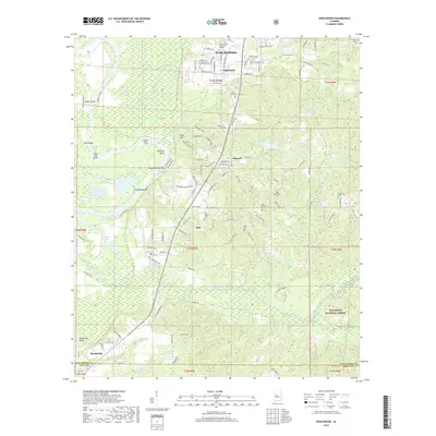
2018 Map of Englewood
USGS Topo · Published 2018About this map
Shelton State Community College stands at the northern edge of this landscape where the suburban expansion of Tuscaloosa meets the rural reaches of the Talladega National Forest. The geography is defined by the winding course of Big Sandy Creek and the intricate riverine features of the Black Warrior River, including Maxwell Bend and Tussels Bar. Smaller communities like Englewood, Maxwell, and Hull are scattered across the terrain, each anchored by local landmarks such as Little Sandy Cem and Big Sandy Cem. The transition from the dense wetlands of Englewood Swamp to the upland rises of Kings Mountain illustrates the varied topography south of the city. Genealogists will find a high density of rural burial grounds, from Gilgal Cem in the northeast to Hulls Cem further south, providing a detailed record of the families who settled this part of Alabama.
Find a feature on this map
125 named features on this map. Tap any name to fly to it.
Don’t see what you’re looking for? This feature index may not catch every label — zoom into the map to look around manually.
Map Details
Editions of this 2018 Englewood Map
This is the sole edition of this map. No revisions or reprints were ever made.
Other maps of this area

1899 · Brookwood
USGS Topo · 1:125,000

1924 · Tuscaloosa
USGS Topo · 1:62,500

1926 · Tuscaloosa
USGS Topo · 1:62,500

1931 · Cottondale
USGS Topo · 1:48,000

1934 · Cottondale
USGS Topo · 1:62,500

1953 · Montgomery
USGS Topo · 1:250,000

1953 · Birmingham
USGS Topo · 1:250,000

1956 · Birmingham
USGS Topo · 1:250,000

1956 · Montgomery
USGS Topo · 1:250,000

1957 · Birmingham
USGS Topo · 1:250,000