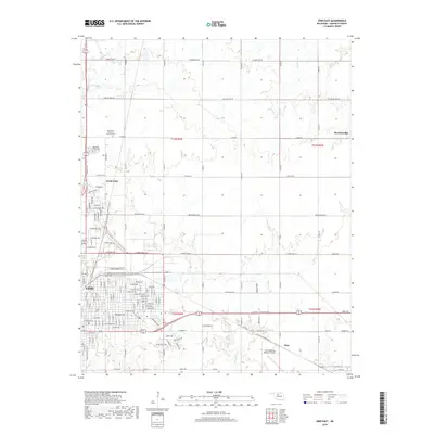
2018 Map of Enid East
USGS Topo · Published 2018About this map
The city of Enid and its eastern surroundings are characterized by a detailed urban street grid transitioning into the rural agricultural sections of Garfield County. This eastern portion of the city includes the residential expansion of North Enid and the prominent Enid Woodring Regional Airport, an essential transportation hub for the region. The landscape is defined by several drainage systems, including Skeleton Cr, Red Rock Cr, and Boggy Cr, which carve gentle patterns across the plains. Historically significant local sites such as the Mennonite Brethren of Enid Cem and Memorial Park Cem provide important reference points for genealogists tracking local families. To the northeast, the small community of Breckenridge marks the far reach of the township grid, connected to the city by a network of established section-line roads like Breckinridge Rd and Carrier Rd.
Find a feature on this map
66 named features on this map. Tap any name to fly to it.
Don’t see what you’re looking for? This feature index may not catch every label — zoom into the map to look around manually.
Map Details
Editions of this 2018 Enid East Map
This is the sole edition of this map. No revisions or reprints were ever made.
Other maps of this area

1955 · Enid West
USGS Topo · 1:24,000

1955 · Enid East
USGS Topo · 1:24,000

1955 · Enid
USGS Topo · 1:250,000

1956 · Garber
USGS Topo · 1:62,500

1956 · Enid
USGS Topo · 1:62,500

1958 · Enid
USGS Topo · 1:250,000

1968 · Hillsdale
USGS Topo · 1:24,000

1968 · Hunter
USGS Topo · 1:24,000

1968 · Kremlin
USGS Topo · 1:24,000
1982 · Waukomis
USGS Topo · 1:24,000