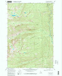
1969 Map of Enos Lake
USGS Topo · Published 1979About this map
Payette National Forest dominates this high-elevation terrain in the Salmon River Mountains, where alpine lakes and deep creek drainages define the landscape. The survey captures the backcountry at a time when access was primarily defined by a network of historic trails. Elevations rise to landmarks like North Loon Mtn and Split Creek Point, while the hydrological system is anchored by the Secesh River flowing through the eastern corridor. This area, documented by the U.S. Geological Survey using mid-century photogrammetric methods, shows a wilderness largely untouched by industrial development. Multiple glacial tarns including Enos Lake, Jungle Lake, and Cow Lake sit at the heads of drainages like Enos Creek and North Fork Lick Creek, providing a detailed view of the remote water systems that feed into the larger river basins of central Idaho.
Find a feature on this map
22 named features on this map. Tap any name to fly to it.
Don’t see what you’re looking for? This feature index may not catch every label — zoom into the map to look around manually.
Map Details
Editions of this 1969 Enos Lake Map
2 editions found
Other maps of this area

1956 · Elk City
USGS Topo · 1:250,000

1957 · Challis
USGS Topo · 1:250,000

1960 · Elk City
USGS Topo · 1:250,000

1960 · Challis
USGS Topo · 1:250,000

1963 · Challis
USGS Topo · 1:250,000

1969 · Loon Lake
USGS Topo · 1:24,000

1969 · Pony Meadows
USGS Topo · 1:24,000

1969 · Enos Lake
USGS Topo · 1:24,000
1969 · Box Lake
USGS Topo · 1:24,000

1969 · Williams Peak
USGS Topo · 1:24,000