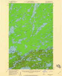
1957 Map of Ensign Lake
USGS Topo · Published 1960About this map
The international border between Canada and the United States bisects this mid-century wilderness landscape, separating the vast Quetico Provincial Park on Hunter Island from the southern reaches of the Superior National Forest. This 1957 field check documents a primitive water-and-portage network before modern development reached the deep interior. A Customs Sta on the border provides a rare point of human infrastructure in a terrain dominated by glacial lakes and narrow waterways. The intricate topography of Ensign Lake and Agnes Lake reflects the complex hydrology of the Boundary Waters, while features like Louisa Falls and Yum Yum Lake highlight the specific nomenclature of the northern backcountry. The map also delineates the northern edge of the Minnesota State Forest, showing the overlapping conservation boundaries that define this region.
Find a feature on this map
93 named features on this map. Tap any name to fly to it.
Don’t see what you’re looking for? This feature index may not catch every label — zoom into the map to look around manually.
Map Details
Editions of this 1957 Ensign Lake Map
2 editions found
Other maps of this area

1954 · Two Harbors
USGS Topo · 1:250,000

1957 · Two Harbors
USGS Topo · 1:250,000

1957 · Gabbro Lake
USGS Topo · 1:62,500

1957 · Ensign Lake
USGS Topo · 1:62,500

1957 · Basswood Lake
USGS Topo · 1:62,500

1957 · Quetico
USGS Topo · 1:250,000

1958 · Two Harbors
USGS Topo · 1:250,000

1959 · Kekekabic Lake
USGS Topo · 1:24,000

1959 · Dutton Lake
USGS Topo · 1:24,000

1960 · Alice Lake
USGS Topo · 1:24,000