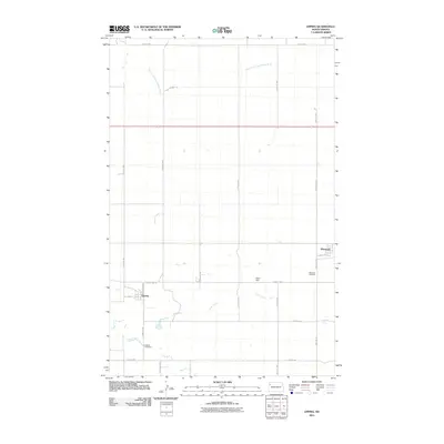
2011 Map of Epping
USGS Topo · Published 2011About this map
Epping and Wheelock anchor this Williams County landscape, where the prairie is defined by a rigorous grid of section lines and watercourses. The drainage of Stony Creek cuts diagonally across the southern half of the quadrangle, while the East Fork Little Muddy River meanders through the north. This 2011 survey captures the spatial relationship between the residential streets of Epping, including Lawrence Ave and 2nd St, and the outlying agricultural infrastructure. Genealogists can identify the precise locations of the Epping Cemetery and the Wheelock Cemetery, while the presence of the Olson Dam indicates localized water management in an area largely dominated by dryland farming and transportation corridors like County Hwy-8 and County Hwy-42.
Find a feature on this map
25 named features on this map. Tap any name to fly to it.
Don’t see what you’re looking for? This feature index may not catch every label — zoom into the map to look around manually.
Map Details
Editions of this 2011 Epping Map
This is the sole edition of this map. No revisions or reprints were ever made.
Other maps of this area

1911 · Ray
USGS Topo · 1:125,000

1953 · Williston
USGS Topo · 1:250,000

1957 · Williston
USGS Topo · 1:250,000

1969 · Cussicks Spring
USGS Topo · 1:24,000

1978 · Ray
USGS Topo · 1:24,000

1978 · Epping NW
USGS Topo · 1:24,000

1978 · Ray NW
USGS Topo · 1:24,000
1978 · Epping NE
USGS Topo · 1:24,000

1978 · Epping
USGS Topo · 1:24,000

1978 · Spring Brook
USGS Topo · 1:24,000