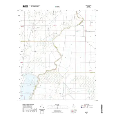
2020 Map of Epps
USGS Topo · Published 2020About this map
Bayou Macon winds through the heart of this landscape, carving a boundary between West Carroll, East Carroll, and Richland Parishes. The village of Epps serves as a local hub near the northern edge, where the grid of Old Delhi Rd and Locust St meets the agricultural flats. This modern survey illustrates a delta region defined by its complex hydrography, where Alligator Bayou, Joes Bayou, and Cypress Bayou drain the low-lying terrain. Genealogy researchers will find numerous rural burial grounds scattered across the parishes, including Palestine Cem, Herringville Cem, and Seven Star Cem. The presence of the Monticello Flying Service near Monticello and the dedicated Poverty Point Pkwy highlights the region's contemporary infrastructure and its connection to the nearby landmark site just south of this quadrangle.
Find a feature on this map
58 named features on this map. Tap any name to fly to it.
Don’t see what you’re looking for? This feature index may not catch every label — zoom into the map to look around manually.
Map Details
Editions of this 2020 Epps Map
This is the sole edition of this map. No revisions or reprints were ever made.
Other maps of this area

1935 · Baskinton
USGS Topo · 1:62,500

1935 · Hurricane
USGS Topo · 1:62,500

1935 · Waverly
USGS Topo · 1:62,500

1955 · Jackson
USGS Topo · 1:250,000

1958 · Baskinton
USGS Topo · 1:62,500

1958 · Hurricane
USGS Topo · 1:62,500

1959 · Mitchiner
USGS Topo · 1:62,500

1961 · Jackson
USGS Topo · 1:250,000

1961 · Waverly
USGS Topo · 1:62,500

1962 · Jackson
USGS Topo · 1:250,000