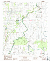
1986 Map of Epps
USGS Topo · Published 1987About this map
Macon Bayou and Joes Bayou wind through this northeast Louisiana landscape, defining the boundaries where West Carroll, East Carroll, Richland, and Madison Parishes meet. The village of Epps serves as the primary hub, showing a concentrated grid of streets and municipal features including a Sewage Disposal Pond. The surrounding agricultural lands are crisscrossed by a network of drainage bayous and small settlements like Mitchiner, Warden, and Monticello, reflecting the rural character of the region in the mid-1980s.
Find a feature on this map
20 named features on this map. Tap any name to fly to it.
Don’t see what you’re looking for? This feature index may not catch every label — zoom into the map to look around manually.
Map Details
Editions of this 1986 Epps Map
This is the sole edition of this map. No revisions or reprints were ever made.
Other maps of this area

1935 · Baskinton
USGS Topo · 1:62,500

1935 · Hurricane
USGS Topo · 1:62,500

1935 · Waverly
USGS Topo · 1:62,500

1955 · Jackson
USGS Topo · 1:250,000

1958 · Baskinton
USGS Topo · 1:62,500

1958 · Hurricane
USGS Topo · 1:62,500

1959 · Mitchiner
USGS Topo · 1:62,500

1961 · Jackson
USGS Topo · 1:250,000

1961 · Waverly
USGS Topo · 1:62,500

1962 · Jackson
USGS Topo · 1:250,000