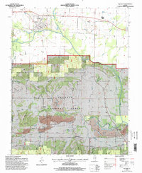
1996 Map of Equality
USGS Topo · Published 1998About this map
The Saline River and its North Fork define the drainage of this Gallatin County landscape, where the flat river bottoms meet the rising elevations of the Wild Cat Hills and Gold Hill. This area is characterized by a legacy of resource extraction, visible in the numerous Strip Mines and several Reclaimed Strip Mines that mark the terrain near Eagle Creek. A distinctive historical landmark is the Negro Spring Salt Well, situated just north of the Shawnee National Forest boundary, pointing to the region's early industrial history in salt production.
Find a feature on this map
49 named features on this map. Tap any name to fly to it.
Don’t see what you’re looking for? This feature index may not catch every label — zoom into the map to look around manually.
Map Details
Editions of this 1996 Equality Map
This is the sole edition of this map. No revisions or reprints were ever made.
Other maps of this area

1905 · Eldorado
USGS Topo · 1:62,500

1905 · New Haven
USGS Topo · 1:62,500

1906 · New Haven
USGS Topo · 1:62,500

1906 · Eldorado
USGS Topo · 1:62,500

1916 · Shawneetown
USGS Topo · 1:62,500

1916 · Equality
USGS Topo · 1:62,500

1949 · Paducah
USGS Topo · 1:250,000

1949 · New Haven
USGS Topo · 1:62,500

1950 · Paducah
USGS Topo · 1:250,000

1954 · Paducah
USGS Topo · 1:250,000