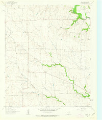
1961 Map of Era SE
USGS Topo · Published 1963About this map
Plainview serves as a central landmark in this 1961 Texas survey, situated among the rolling divides of the Hickory Creek watershed. The landscape is defined by the convergence of North Hickory Creek and South Hickory Creek, which carve distinct drainage patterns across the terrain. To the northeast, the Bolivar Oil Field indicates the localized reach of the petroleum industry, evidenced by several scattered Oil Wells near the banks of Clear Creek. This map reveals a rural economy dependent on both ranching and natural resources, with prominent property boundaries indicated by fine red dashed lines and water management features like a Water Tank and several small branches including Burns Branch and Boom. It is a precise record of the Denton County countryside before significant modern development altered these traditional drainage and property lines.
Find a feature on this map
10 named features on this map. Tap any name to fly to it.
Don’t see what you’re looking for? This feature index may not catch every label — zoom into the map to look around manually.
Map Details
Editions of this 1961 Era SE Map
2 editions found
Other maps of this area

1954 · Sherman
USGS Topo · 1:250,000

1958 · Sherman
USGS Topo · 1:250,000

1959 · Ponder
USGS Topo · 1:24,000

1960 · Sanger
USGS Topo · 1:24,000

1960 · Bluett
USGS Topo · 1:24,000
1960 · Denton West
USGS Topo · 1:24,000

1961 · Era
USGS Topo · 1:24,000

1961 · Slidell
USGS Topo · 1:24,000

1961 · Valley View
USGS Topo · 1:24,000
1961 · Greenwood
USGS Topo · 1:24,000