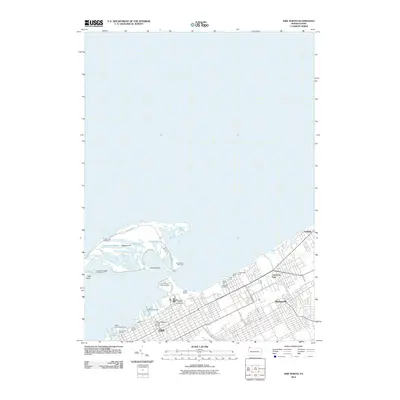
2010 Map of Erie North
USGS Topo · Published 2010About this map
Presque Isle dominates the lakefront of this 2010 survey, showcasing the complex maritime and recreational geography of Erie. The peninsula is a landscape of interior water bodies like Cranberry Pond and Ridge Pond, anchored by the Presque Isle Lighthouse. Along the mainland, the map details a densely developed urban and industrial corridor stretching from the Erie International Main Terminal eastward through Lawrence Park and Wesleyville.
Find a feature on this map
41 named features on this map. Tap any name to fly to it.
Don’t see what you’re looking for? This feature index may not catch every label — zoom into the map to look around manually.
Map Details
Editions of this 2010 Erie North Map
This is the sole edition of this map. No revisions or reprints were ever made.
Other maps of this area

1899 · Erie
USGS Topo · 1:62,500

1900 · Erie
USGS Topo · 1:62,500

1913 · North East
USGS Topo · 1:62,500

1915 · North East
USGS Topo · 1:62,500

1943 · North East
USGS Topo · 1:62,500

1950 · Erie
USGS Topo · 1:250,000

1957 · Erie South
USGS Topo · 1:24,000
1957 · Swanville
USGS Topo · 1:24,000
1957 · Erie North
USGS Topo · 1:24,000

1959 · Erie
USGS Topo · 1:250,000
Featured Places
- Erie, PA
- Harborcreek Township, PA
- Lawrence Park Township, PA
- Wesleyville, PA
- Fairfield, Harborcreek Township