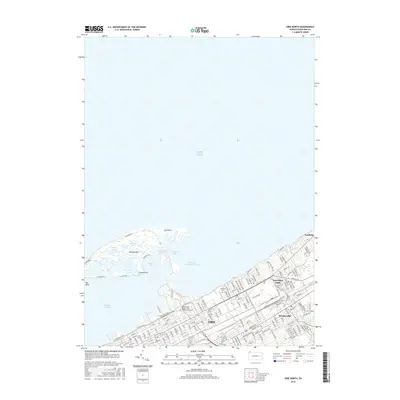
2016 Map of Erie North
USGS Topo · Published 2016About this map
Presque Isle arc across the northern horizon of this survey, protecting the waters of Presque Isle Bay and the Erie Harbor Entrance Channel. This distinctive sand spit formation is detailed with its interior lagoons and points, including Cranberry Pond, Ridge Pond, Misery Bay, and Gull Point. The urban interface of Erie meets the shoreline with a structured grid of streets and specialized infrastructure like the Port Access Rd and the W Bayfront Pkwy.
Find a feature on this map
30 named features on this map. Tap any name to fly to it.
Don’t see what you’re looking for? This feature index may not catch every label — zoom into the map to look around manually.
Map Details
Editions of this 2016 Erie North Map
This is the sole edition of this map. No revisions or reprints were ever made.
Other maps of this area

1899 · Erie
USGS Topo · 1:62,500

1900 · Erie
USGS Topo · 1:62,500

1913 · North East
USGS Topo · 1:62,500

1915 · North East
USGS Topo · 1:62,500

1943 · North East
USGS Topo · 1:62,500

1950 · Erie
USGS Topo · 1:250,000

1957 · Erie South
USGS Topo · 1:24,000
1957 · Swanville
USGS Topo · 1:24,000
1957 · Erie North
USGS Topo · 1:24,000

1959 · Erie
USGS Topo · 1:250,000
Featured Places
- Erie, PA
- Harborcreek Township, PA
- Lawrence Park Township, PA
- Wesleyville, PA
- Fairfield, Harborcreek Township