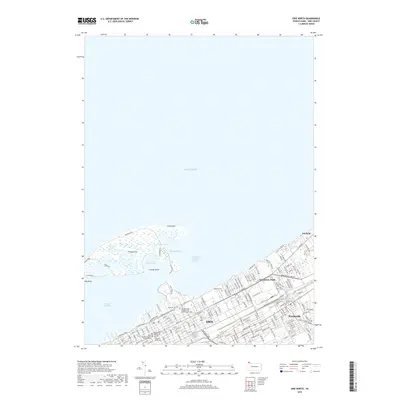
2019 Map of Erie North
USGS Topo · Published 2019About this map
Presque Isle creates a natural sheltered harbor for Erie, Pennyslvania, protecting the city's waterfront with its distinctive curving peninsula. The urban grid is densely packed south of Presque Isle Bay, extending from the Erie County Courthouse and Gannon University out through the industrial and residential corridors of Lawrence Park and Wesleyville. This 2019 survey documents the complex interface between the Great Lakes shoreline and the city's civic infrastructure, including historic religious and military sites like Saint Paul's Cathedral and the Pennsylvania Soldiers' and Sailor's Home Cem.
Find a feature on this map
33 named features on this map. Tap any name to fly to it.
Don’t see what you’re looking for? This feature index may not catch every label — zoom into the map to look around manually.
Map Details
Editions of this 2019 Erie North Map
This is the sole edition of this map. No revisions or reprints were ever made.
Other maps of this area

1899 · Erie
USGS Topo · 1:62,500

1900 · Erie
USGS Topo · 1:62,500

1913 · North East
USGS Topo · 1:62,500

1915 · North East
USGS Topo · 1:62,500

1943 · North East
USGS Topo · 1:62,500

1950 · Erie
USGS Topo · 1:250,000

1957 · Erie South
USGS Topo · 1:24,000
1957 · Swanville
USGS Topo · 1:24,000
1957 · Erie North
USGS Topo · 1:24,000

1959 · Erie
USGS Topo · 1:250,000
Featured Places
- Erie, PA
- Harborcreek Township, PA
- Lawrence Park Township, PA
- Wesleyville, PA
- Fairfield, Harborcreek Township