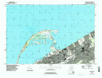
1996 Map of Erie North
USGS Topo · Published 1996About this map
Presque Isle dominates the lakefront, a complex landform sheltering Presque Isle Bay and providing a natural harbor for the city of Erie. This 1996 update shows a densely developed urban core and the adjacent communities of Wesleyville and Fairfield. The landscape is a mix of civic infrastructure and historic institutions, from the State Soldiers and Sailors Home and Hamot Med Ctr to numerous parochial schools like St Stanislaus Sch and St Benedicts Academy.
Find a feature on this map
70 named features on this map. Tap any name to fly to it.
Don’t see what you’re looking for? This feature index may not catch every label — zoom into the map to look around manually.
Map Details
Editions of this 1996 Erie North Map
This is the sole edition of this map. No revisions or reprints were ever made.
Other maps of this area

1899 · Erie
USGS Topo · 1:62,500

1900 · Erie
USGS Topo · 1:62,500

1913 · North East
USGS Topo · 1:62,500

1915 · North East
USGS Topo · 1:62,500

1943 · North East
USGS Topo · 1:62,500

1950 · Erie
USGS Topo · 1:250,000

1957 · Erie South
USGS Topo · 1:24,000
1957 · Swanville
USGS Topo · 1:24,000
1957 · Erie North
USGS Topo · 1:24,000

1959 · Erie
USGS Topo · 1:250,000
Featured Places
- Erie, PA
- Harborcreek Township, PA
- Lawrence Park Township, PA
- Wesleyville, PA
- Fairfield, Harborcreek Township