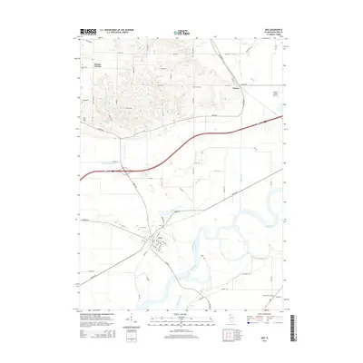
2015 Map of Erie
USGS Topo · Published 2015About this map
Erie serves as the primary population center in this Whiteside County landscape, situated where several local roads and the Rock River basin converge. The town's grid is clearly defined by local streets such as Main St and 16th Ave, while its surroundings reveal a transition from agricultural uplands into the complex drainage systems of the river valley. Numerous sloughs, including Hadaway Slough and Carson Slough, crisscross the bottomlands south of the village, illustrating the intricate hydrology of this portion of Illinois. To the north, the smaller settlement of Fenton and the landmark Newton Corners anchor the rural road network. Genealogists and local historians will find several well-defined burial sites across the township, including Smack Cem, Fenton Cem, and the remote Shady Town Cem located in the southeastern corner near the river's bend.
Find a feature on this map
63 named features on this map. Tap any name to fly to it.
Don’t see what you’re looking for? This feature index may not catch every label — zoom into the map to look around manually.
Map Details
Editions of this 2015 Erie Map
This is the sole edition of this map. No revisions or reprints were ever made.
Other maps of this area

1891 · Clinton
USGS Topo · 1:62,500

1894 · Clinton
USGS Topo · 1:62,500

1899 · Clinton
USGS Topo · 1:125,000

1932 · Prophetstown
USGS Topo · 1:48,000

1934 · Morrison
USGS Topo · 1:48,000

1936 · Prophetstown
USGS Topo · 1:62,500

1940 · Morrison
USGS Topo · 1:62,500

1952 · Erie
USGS Topo · 1:62,500

1952 · Clinton
USGS Topo · 1:62,500
1953 · Clinton
USGS Topo · 1:24,000