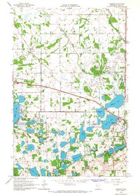
1966 Map of Erskine
USGS Topo · Published 1967About this map
The village of Erskine serves as the hub of this Polk County landscape, situated at the junction of the Great Northern railroad and a dense network of glacial lakes and wetlands. The mid-1960s terrain is defined by its transition from prairie to water, evidenced by the sprawling Erskine State Wildlife Management Area and numerous other protected zones like the Bee Lake State Wildlife Management Area. Rural life is centered around local institutions such as Saron Ch, Broderheim Ch, and Rodnes Ch, which anchor the townships of Grove Park, Badger, Woodside, and Knute. To the north, the Poplar River and Upper Badger Creek drain the undulating fields, while Judicial Ditch No 73 illustrates the region's managed hydrology. This survey captures a moment when the shoreline of Maple Lake and Cameron Lake remained largely defined by nature rather than dense development.
Find a feature on this map
31 named features on this map. Tap any name to fly to it.
Don’t see what you’re looking for? This feature index may not catch every label — zoom into the map to look around manually.
Map Details
Editions of this 1966 Erskine Map
This is the sole edition of this map. No revisions or reprints were ever made.
Other maps of this area

1918 · Terrebonne
USGS Topo · 1:62,500

1919 · Grit
USGS Topo · 1:62,500

1919 · Valley
USGS Topo · 1:62,500

1952 · Grand Forks
USGS Topo · 1:250,000

1954 · Bemidji
USGS Topo · 1:250,000

1956 · Grand Forks
USGS Topo · 1:250,000

1957 · Bemidji
USGS Topo · 1:250,000

1958 · Bemidji
USGS Topo · 1:250,000

1964 · Terrebonne
USGS Topo · 1:24,000

1964 · Brooks
USGS Topo · 1:24,000