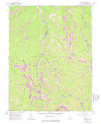
1965 Map of Eskdale
USGS Topo · Published 1977About this map
Cabin Creek and its many winding tributaries define this coal-rich landscape south of the Kanawha River during the mid-1960s. The valley is densely packed with mining infrastructure and company towns, connected by the Chesapeake and Ohio railroad which serves high-activity areas like the Cane Fork Yards. The map documents a transition in extraction methods, where traditional subsurface Coal Mines and the Powerhouse at Holly exist alongside expanding Strip Mine operations that crown the ridges. Community life is centered in narrow valleys at Eskdale, Kayford, and Decota, where local landmarks like the Wake Forest Sch and St Johns Ch served the families of the Kanawha and Boone County borderlands. Extensive rail spurs, including the C & O, weave through the hollows to reach remote sites like Republic and Wevaco.
Find a feature on this map
69 named features on this map. Tap any name to fly to it.
Don’t see what you’re looking for? This feature index may not catch every label — zoom into the map to look around manually.
Map Details
Editions of this 1965 Eskdale Map
2 editions found
Other maps of this area

1891 · Oceana
USGS Topo · 1:125,000

1891 · Raleigh
USGS Topo · 1:125,000

1893 · Oceana
USGS Topo · 1:125,000

1897 · Kanawha Falls
USGS Topo · 1:125,000

1897 · Raleigh
USGS Topo · 1:125,000

1898 · Oceana
USGS Topo · 1:125,000

1899 · Charleston
USGS Topo · 1:125,000

1900 · Kanawha Falls
USGS Topo · 1:125,000

1901 · Kanawha Falls
USGS Topo · 1:125,000

1902 · Raleigh
USGS Topo · 1:125,000