
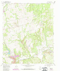
1969 Map of Eskota
USGS Topo · Published 1972About this map
Palava and Eskota anchor this 1969 topographic study of West Texas, where the landscape is defined by the drainage basins of Sweetwater Creek and its many tributaries. The area's transportation and ranching economy is evident through the parallel routes of the Atchison Topeka and Santa Fe and the Texas Pacific railroads crossing the southern half of the map. Significant land use detail is captured through the labeling of various Gravel Pits and a large Spillway near Willow Tank.
Find a feature on this map
18 named features on this map. Tap any name to fly to it.
Don’t see what you’re looking for? This feature index may not catch every label — zoom into the map to look around manually.
Map Details
Editions of this 1969 Eskota Map
2 editions found
Other maps of this area

1893 · Roby
USGS Topo · 1:125,000

1893 · Sweetwater
USGS Topo · 1:125,000

1954 · Big Spring
USGS Topo · 1:250,000

1957 · Merkel
USGS Topo · 1:62,500

1957 · Noodle
USGS Topo · 1:62,500

1958 · Big Spring
USGS Topo · 1:250,000

1969 · Busby
USGS Topo · 1:24,000
1969 · Roby
USGS Topo · 1:24,000

1969 · Sweetwater
USGS Topo · 1:24,000
1969 · Longworth
USGS Topo · 1:24,000