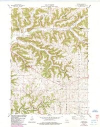
1983 Map of Esofea
USGS Topo · Published 1985About this map
The Driftless Area of Vernon County is defined here by a network of deeply incised coulees and prominent ridges, where agriculture and small settlements like Esofea and Coon Valley follow the winding valley floors. At the intersection of the townships of Coon, Christiana, and Jefferson, the landscape reveals a clear pattern of land use where narrow ridgetop roads like Bohemian Ridge Road connect isolated farmsteads above the drainage basins of the North Fork Coon Creek and the Bad Axe River. Cultural centers of the early 1980s are preserved through labels for Skogdalen Ch and Bethany Ch, while recreational spaces such as Von Ruden Memorial Park and Esofea Park highlight the community life of this rural region. The map also records the presence of local industry through several quarries and a gravel pit, marking points of resource extraction within the rugged topography of the Viroqua Prairie edge.
Find a feature on this map
45 named features on this map. Tap any name to fly to it.
Don’t see what you’re looking for? This feature index may not catch every label — zoom into the map to look around manually.
Map Details
Editions of this 1983 Esofea Map
2 editions found
Other maps of this area

1909 · Sparta
USGS Topo · 1:62,500

1923 · Viroqua
USGS Topo · 1:62,500

1926 · Stoddard
USGS Topo · 1:62,500

1926 · Viroqua
USGS Topo · 1:62,500

1927 · La Crosse
USGS Topo · 1:62,500

1930 · La Crosse
USGS Topo · 1:62,500

1947 · Sparta
USGS Topo · 1:62,500

1949 · Sparta
USGS Topo · 1:62,500

1958 · La Crosse
USGS Topo · 1:250,000

1961 · La Crosse
USGS Topo · 1:250,000