
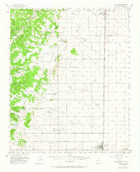
1956 Map of Estancia
USGS Topo · Published 1958About this map
Estancia and the surrounding high plains of the Estancia Valley are documented here during the mid-1950s, a period defined by ranching and the transit corridor of the Atchison Topeka and Santa Fe railroad. To the west, the landscape rises into the timbered terrain of the Chilili Grant, where the historic settlement of Chilili and the site of Old Chilili are positioned along the Arroyo de Chilili. This area showcases a distinct transition from the forested mountain slopes to the flat, alkaline basins that characterize this part of New Mexico.
Find a feature on this map
56 named features on this map. Tap any name to fly to it.
Don’t see what you’re looking for? This feature index may not catch every label — zoom into the map to look around manually.
Map Details
Editions of this 1956 Estancia Map
2 editions found
Other maps of this area

1892 · San Pedro
USGS Topo · 1:125,000

1894 · Lamy
USGS Topo · 1:125,000

1917 · Estancia
USGS Topo · 1:125,000

1954 · Chilili
USGS Topo · 1:24,000

1954 · Torreon
USGS Topo · 1:24,000

1954 · Sedillo
USGS Topo · 1:24,000

1954 · Tajique
USGS Topo · 1:24,000

1954 · Escabosa
USGS Topo · 1:24,000

1954 · Edgewood
USGS Topo · 1:24,000

1954 · Milbourn Ranch
USGS Topo · 1:24,000