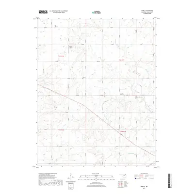
2019 Map of Estella
USGS Topo · Published 2019About this map
Estella forms the focal point of this rural Craig County landscape, where the prairie is etched by a network of drainage systems including Thompson Cr and White Cr. The map reveals a high concentration of historical burial sites, often associated with family names or small community centers, such as Timpson Chapel Cem, Deal Cem, and Longtail Cem. These sites, along with Saint Augustine Cem and Scott Cem, point to a long-established settlement pattern deeply rooted in the land. The terrain is characterized by gentle undulations and a rigid sectional grid of roads, though the path of local waterways like Lightning Cr and Pawpaw Cr breaks the symmetry of the surveyed lines. The presence of Ratcliff Ranch Airport indicates how the region's agricultural expanse adapted to modern transport while maintaining its quiet, dispersed character.
Find a feature on this map
40 named features on this map. Tap any name to fly to it.
Don’t see what you’re looking for? This feature index may not catch every label — zoom into the map to look around manually.
Map Details
Editions of this 2019 Estella Map
This is the sole edition of this map. No revisions or reprints were ever made.
Other maps of this area

1901 · Vinita
USGS Topo · 1:125,000

1913 · Vinita
USGS Topo · 1:125,000

1954 · Tulsa
USGS Topo · 1:250,000

1958 · Tulsa
USGS Topo · 1:250,000

1963 · Tulsa
USGS Topo · 1:250,000

1970 · Chelsea
USGS Topo · 1:24,000

1970 · White Oak
USGS Topo · 1:24,000
1971 · Pyramid Corners
USGS Topo · 1:24,000
1971 · Big Cabin
USGS Topo · 1:24,000
1971 · Vinita
USGS Topo · 1:24,000