
1970 Map of White Oak
USGS Topo · Published 1972About this map
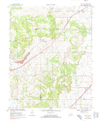
The St Louis-San Francisco railroad cuts a sharp diagonal through this corner of the Cherokee Nation at the dawn of the 1970s, anchoring settlements like White Oak and Catale. While the Will Rogers Toll Road Turnpike introduces a modern high-speed thoroughfare in the southeast, much of the landscape remains defined by its older agricultural and industrial roots. The Catale Oil Field and scattered mines point to a history of resource extraction, while local genealogy is preserved at sites like Shawnee Cem, White Oak Cem, and Condry Ch. These small community landmarks, alongside Council Grove Ch, suggest a rural social structure oriented around the headwaters of Pryor Creek and White Oak Creek. The terrain is a mix of wooded creek bottoms and open upland, showing the transitional character of the region as it borders Craig, Rogers, and Mayes Counties.
Find a feature on this map
28 named features on this map. Tap any name to fly to it.
Don’t see what you’re looking for? This feature index may not catch every label — zoom into the map to look around manually.
Map Details
Editions of this 1970 White Oak Map
2 editions found
Other maps of this area

1896 · Pryor
USGS Topo · 1:125,000

1901 · Vinita
USGS Topo · 1:125,000

1901 · Pryor
USGS Topo · 1:125,000

1913 · Vinita
USGS Topo · 1:125,000

1954 · Tulsa
USGS Topo · 1:250,000

1958 · Tulsa
USGS Topo · 1:250,000

1963 · Tulsa
USGS Topo · 1:250,000

1969 · Adair
USGS Topo · 1:24,000
1970 · Bushyhead
USGS Topo · 1:24,000

1970 · Chelsea
USGS Topo · 1:24,000