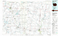
1985 Map of Estherville
USGS Topo · Published 1985About this map
Estherville and Emmetsburg serve as the primary hubs in this mid-1980s layout of northern Iowa, where the Des Moines River and an extensive network of drainage ditches define the agricultural landscape. The region’s glacial heritage is evident in the dense concentration of wetlands and lakes, many protected as state wildlife management areas like Swan Lake and Christopherson Slough and the expansive Union Slough National Wildlife Refuge. The map details a transition in transportation, showing the established routes of the Chicago and North Western and the Chicago Milwaukee St Paul and Pacific railroads alongside small-town infrastructure. Smaller locales such as Crippin Corners, Gruver, and Ringsted dot the sections, while sites like Oak Hill Cemetery and the Fourmile Lake School provide specific points of interest for those tracing local family history or the placement of early rural institutions.
Find a feature on this map
130 named features on this map. Tap any name to fly to it.
Don’t see what you’re looking for? This feature index may not catch every label — zoom into the map to look around manually.
Map Details
Editions of this 1985 Estherville Map
2 editions found
Other maps of this area

1954 · Fairmont
USGS Topo · 1:250,000

1954 · Mason City
USGS Topo · 1:250,000

1954 · Waterloo
USGS Topo · 1:250,000

1954 · Fort Dodge
USGS Topo · 1:250,000

1955 · Waterloo
USGS Topo · 1:250,000

1955 · Bricelyn
USGS Topo · 1:62,500

1957 · Fort Dodge
USGS Topo · 1:250,000

1957 · Mason City
USGS Topo · 1:250,000

1958 · Mason City
USGS Topo · 1:250,000

1958 · Fort Dodge
USGS Topo · 1:250,000