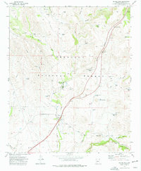
1974 Map of Estler Peak
USGS Topo · Published 1977About this map
Quarter Circle V Bar Ranch and the nearby Orme Ranch Airstrip anchor the central portion of this 1970s landscape, illustrating the blend of private ranching operations within the protected borders of the Prescott National Forest. The terrain is characterized by a complex drainage system where Ash Creek, Cienega Creek, and Yarber Wash carve through the high country. Livestock management is the primary human footprint across these canyons, evidenced by a dense network of water features like Black Butte Tank, Old East Side Tank, and Cedar Tank.
Find a feature on this map
39 named features on this map. Tap any name to fly to it.
Don’t see what you’re looking for? This feature index may not catch every label — zoom into the map to look around manually.
Map Details
Editions of this 1974 Estler Peak Map
2 editions found
Other maps of this area

1887 · Verde
USGS Topo · 1:250,000

1887 · Prescott
USGS Topo · 1:250,000

1892 · Verde
USGS Topo · 1:250,000

1892 · Prescott
USGS Topo · 1:250,000

1903 · Bradshaw Mountains
USGS Topo · 1:125,000

1905 · Jerome
USGS Topo · 1:125,000

1923 · Camp Verde
USGS Topo · 1:125,000

1929 · Turret Peak
USGS Topo · 1:125,000

1932 · Camp Verde
USGS Topo · 1:125,000

1933 · Turret Peak
USGS Topo · 1:125,000