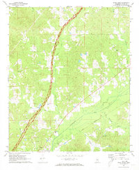
1972 Map of Ethel North
USGS Topo · Published 1973About this map
The town of Ethel anchors the southern portion of this central Mississippi landscape, situated at the junction of the Illinois Central railroad and local rural routes. Much of the terrain is defined by the winding course of the Yockanookany River and its numerous tributaries, including Zilpha Creek, Cole Creek, and Black Creek. The Natchez Trace Parkway cuts a prominent north-south path through the center of the sheet, tracing the historic travel corridor through Attala County. The map reveals a deeply rooted rural community, marked by a high density of country churches and small burial grounds. Local landmarks like the Greenlee Sch and Hannah Cem suggest the long-standing family settlements that have shaped this region. To the north, the terrain remains predominantly undeveloped, with narrow creek bottoms like Panther Creek and Holly Branch threading through the timbered hills.
Find a feature on this map
29 named features on this map. Tap any name to fly to it.
Don’t see what you’re looking for? This feature index may not catch every label — zoom into the map to look around manually.
Map Details
Editions of this 1972 Ethel North Map
This is the sole edition of this map. No revisions or reprints were ever made.
Other maps of this area

1953 · West Point
USGS Topo · 1:250,000

1958 · West Point
USGS Topo · 1:250,000

1963 · West Point
USGS Topo · 1:250,000

1964 · Kosciusko NE
USGS Topo · 1:24,000

1964 · Kosciusko
USGS Topo · 1:24,000

1966 · Poplar Creek
USGS Topo · 1:24,000

1966 · Kosciusko
USGS Topo · 1:62,500

1966 · Weir
USGS Topo · 1:24,000

1966 · French Camp
USGS Topo · 1:24,000

1968 · Weir
USGS Topo · 1:62,500