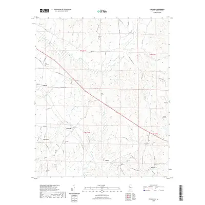
2020 Map of Ethelsville
USGS Topo · Published 2020About this map
Ethelsville and the surrounding rural communities of Macedonia and Stafford anchor this Pickens County landscape, defined by a dense network of country roads and small family cemeteries. The terrain is deeply incised by drainages like Magby Creek and Burdine Creek, which create a complex pattern of ridges where long-standing homesteads and churches are situated. Numerous historic burial sites, such as Forest Church Cemetery, Providence Cemetery, and the Old El Bethel Cemetery, are scattered throughout the quadrangle, serving as vital markers for local genealogical research. In the southeastern corner, the settlement of McShan and the nearby Delma area show the continued importance of regional connectors like the corridor between Ethelsville and the neighboring hills. The map captures a high level of detail for rural road systems, including Bains Road and County Road 34, tracing the way these routes follow the natural topography of the Alabama-Mississippi borderlands.
Find a feature on this map
76 named features on this map. Tap any name to fly to it.
Don’t see what you’re looking for? This feature index may not catch every label — zoom into the map to look around manually.
Map Details
Editions of this 2020 Ethelsville Map
This is the sole edition of this map. No revisions or reprints were ever made.
Other maps of this area

1953 · West Point
USGS Topo · 1:250,000

1958 · West Point
USGS Topo · 1:250,000

1960 · Caledonia
USGS Topo · 1:62,500

1960 · Columbus
USGS Topo · 1:62,500

1963 · West Point
USGS Topo · 1:250,000

1966 · Ethelsville
USGS Topo · 1:24,000

1966 · Reform SW
USGS Topo · 1:24,000

1967 · Carrollton
USGS Topo · 1:24,000

1967 · Millport
USGS Topo · 1:24,000
1967 · Reform
USGS Topo · 1:24,000