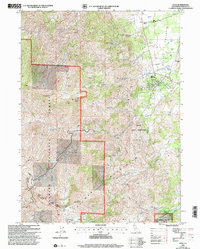
2001 Map of Etna
USGS Topo · Published 2004About this map
Etna sits at the western edge of the valley, serving as a gateway between the agricultural lands along the Scott River and the steep terrain of the Klamath Mountains. This 2001 revision by the Forest Service highlights a landscape where water management is central, visible through the Aqueduct and Sewage Disposal Ponds near the town center. The map documents local history through sites like the Deacon Lee Place (Site) and an Historical Marker located north of town along the river corridor.
Find a feature on this map
44 named features on this map. Tap any name to fly to it.
Don’t see what you’re looking for? This feature index may not catch every label — zoom into the map to look around manually.
Map Details
Editions of this 2001 Etna Map
2 editions found
Other maps of this area

1886 · Shasta
USGS Topo · 1:250,000

1894 · Shasta
USGS Topo · 1:250,000

1914 · Seiad
USGS Topo · 1:125,000

1922 · Seiad
USGS Topo · 1:125,000

1923 · Sawyers Bar
USGS Topo · 1:125,000

1931 · Etna
USGS Topo · 1:96,000

1932 · Yreka
USGS Topo · 1:96,000

1934 · Etna
USGS Topo · 1:125,000

1939 · Yreka
USGS Topo · 1:125,000

1948 · Weed
USGS Topo · 1:250,000