1935 Map of Etowah
USGS Topo · Published 1935About this map
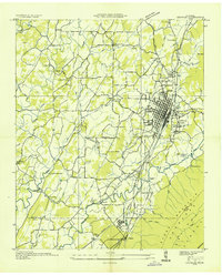
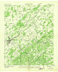
Etowah stands as a significant railroad hub in the Tennessee Valley during the mid-1930s, anchored by the Louisville and Nashville rail corridor. The map reveals a landscape defined by industrial extraction and rural community life, featuring Davis Quarry and a Limestone Quarry alongside numerous local institutions like Wesleyana Sch and Jones Chapel. The eastern edge is dominated by the rising elevations of Starr Mountain within the Cherokee National Forest, while the lowland areas are networked by water sources like Conasauga River and Chestuee Creek. Smaller settlements such as Delano and Cog Hill demonstrate the era's decentralized population pattern, supported by local infrastructure like the Etowah Water Works near Fowler Spring. This survey captures the transition from the river-fed agricultural valleys to the industrial rail yards and forested ridges of McMinn and Polk counties.
Find a feature on this map
85 named features on this map. Tap any name to fly to it.
Don’t see what you’re looking for? This feature index may not catch every label — zoom into the map to look around manually.
Map Details
Editions of this 1935 Etowah Map
This is the sole edition of this map. No revisions or reprints were ever made.
Other maps of this area

1886 · Cleveland
USGS Topo · 1:125,000

1892 · Cleveland
USGS Topo · 1:125,000

1893 · Murphy
USGS Topo · 1:125,000

1895 · Cleveland
USGS Topo · 1:125,000

1901 · Cleveland
USGS Topo · 1:125,000

1914 · Murphy
USGS Topo · 1:125,000

1934 · Mecca
USGS Topo · 1:24,000
1934 · Englewood
USGS Topo · 1:24,000

1935 · Tellico
USGS Topo · 1:48,000
1935 · Calhoun
USGS Topo · 1:24,000