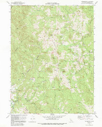
1969 Map of Ettersburg
USGS Topo · Published 1991About this map
Ettersburg serves as a small focal point in this remote corner of Humboldt County, situated near the Mattole River and Blue Slide Creek. The 1969 landscape is defined by the sharp verticality of the King Range area, where Elk Ridge and Telegraph Ridge run as massive parallel spines. To the northeast, the corner of Humboldt Redwoods State Park touches the map, while family-named properties like Briceland Ranch and Phelps Ranch dot the more accessible drainage areas.
Find a feature on this map
24 named features on this map. Tap any name to fly to it.
Don’t see what you’re looking for? This feature index may not catch every label — zoom into the map to look around manually.
Map Details
Editions of this 1969 Ettersburg Map
3 editions found
Other maps of this area

1919 · Glynn
USGS Topo · 1:62,500

1920 · Pt. Delagda
USGS Topo · 1:62,500

1921 · Dyerville
USGS Topo · 1:62,500

1921 · Briceland
USGS Topo · 1:62,500

1949 · Eureka
USGS Topo · 1:250,000

1949 · Point Delgada
USGS Topo · 1:62,500

1949 · Garberville
USGS Topo · 1:62,500

1949 · Weott
USGS Topo · 1:62,500

1950 · Scotia
USGS Topo · 1:62,500

1951 · Scotia
USGS Topo · 1:62,500