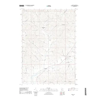
2018 Map of Ettrick
USGS Topo · Published 2018About this map
Ettrick serves as the primary hub of this Trempealeau County landscape, situated near the confluence of Beaver Creek and several distinct valley systems. The local geography is defined by narrow coulees and steep ridges, with settlements like Frenchville and Upper French Creek following the natural contours of the land. This survey illustrates a rural infrastructure built around family-named landmarks and coulees, such as Linderud Coulee, Abraham Coulee, and Smikrud Coulee, reflecting a long-standing settlement pattern where transport routes like Co Rd D and Co Rd TT trace the valley floors. Historical and genealogical interest is anchored by several local burial grounds, including Saint Bridget Cem and Vor Frelsers Cem. Notable heights such as Johnson Peak and Peacock Hill rise above the drainage networks of French Cr and Reynolds Coulee Cr, framing a landscape that remains deeply tied to its agricultural and topographic roots.
Find a feature on this map
78 named features on this map. Tap any name to fly to it.
Don’t see what you’re looking for? This feature index may not catch every label — zoom into the map to look around manually.
Map Details
Editions of this 2018 Ettrick Map
This is the sole edition of this map. No revisions or reprints were ever made.
Other maps of this area

1926 · North Bend
USGS Topo · 1:62,500

1926 · Whitehall
USGS Topo · 1:62,500

1927 · Blair
USGS Topo · 1:62,500

1929 · Whitehall
USGS Topo · 1:62,500

1929 · Galesville
USGS Topo · 1:62,500

1929 · North Bend
USGS Topo · 1:62,500

1953 · Eau Claire
USGS Topo · 1:250,000

1958 · Eau Claire
USGS Topo · 1:250,000

1964 · Eau Claire
USGS Topo · 1:250,000
1968 · Blair
USGS Topo · 1:62,500