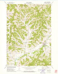
1973 Map of Ettrick
USGS Topo · Published 1975About this map
Ettrick and the surrounding coulees of Trempealeau County are meticulously documented in this mid-1970s survey, showcasing the deeply dissected landscape of western Wisconsin. The settlement pattern follows the intricate valley floors, with small communities like Frenchville, Iduna, and Chapultepec situated along the drainage systems of French Creek and the North Fork and South Fork of the Beaver Creek system. The map is particularly valuable for genealogical research, identifying numerous country burial grounds including Vor Frelsers Cem, Ettrick Cem, and St Bridget Cem. Elevated terrain features like Arcadia Ridge and Peacock Hill frame the narrow agricultural valleys, while landmarks such as the French Creek Ch reflect the area's rural social fabric. The presence of multiple quarries throughout the ridges suggests a local industry focused on the area’s limestone and sandstone deposits, which define the geography between Oak Ridge and American Valley.
Find a feature on this map
31 named features on this map. Tap any name to fly to it.
Don’t see what you’re looking for? This feature index may not catch every label — zoom into the map to look around manually.
Map Details
Editions of this 1973 Ettrick Map
This is the sole edition of this map. No revisions or reprints were ever made.
Other maps of this area

1926 · North Bend
USGS Topo · 1:62,500

1926 · Whitehall
USGS Topo · 1:62,500

1927 · Blair
USGS Topo · 1:62,500

1929 · Whitehall
USGS Topo · 1:62,500

1929 · Galesville
USGS Topo · 1:62,500

1929 · North Bend
USGS Topo · 1:62,500

1953 · Eau Claire
USGS Topo · 1:250,000

1958 · Eau Claire
USGS Topo · 1:250,000

1964 · Eau Claire
USGS Topo · 1:250,000
1968 · Blair
USGS Topo · 1:62,500