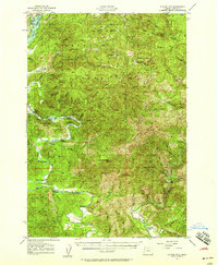
1957 Map of Euchre Mtn
USGS Topo · Published 1958About this map
The Siletz River winds through the heart of the Siuslaw National Forest in this mid-century survey, revealing a landscape defined by timber extraction and riverfront landings. The southwestern portion of the map highlights several water-access points such as Morgan Landing, Mowrey Landing, and Sunset Landing, while the interior is marked by the presence of a Logging R R near the Upper Farm. These features suggest a period when river transport and specialized rail lines were central to the local economy and resource management.
Find a feature on this map
82 named features on this map. Tap any name to fly to it.
Don’t see what you’re looking for? This feature index may not catch every label — zoom into the map to look around manually.
Map Details
Editions of this 1957 Euchre Mtn Map
3 editions found
Other maps of this area

1939 · Marys Peak
USGS Topo · 1:62,500

1941 · Nestucca Bay
USGS Topo · 1:62,500

1941 · Cape Foulweather
USGS Topo · 1:62,500

1942 · Euchre Mtn
USGS Topo · 1:62,500

1942 · Marys Peak
USGS Topo · 1:62,500

1942 · Spirit Mtn
USGS Topo · 1:62,500

1942 · Nestucca Bay
USGS Topo · 1:62,500

1942 · Yaquina
USGS Topo · 1:62,500

1942 · Valsetz
USGS Topo · 1:62,500

1942 · Toledo
USGS Topo · 1:62,500