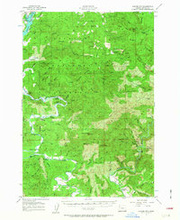
1957 Map of Euchre Mtn
USGS Topo · Published 1963About this map
The Siletz River winds through a heavily forested landscape dominated by the Siuslaw National Forest during the mid-1950s. This coastal region is defined by its reliance on the river and its many landings, such as Sunset Landing, Melco Landing, and Mack Landing, which served as vital access points for local industry and transport. Higher elevations are marked by landmarks like Euchre Mtn and Cougar Mtn, while the lowlands near Devils Lake show the growth of Oceanlake and Neotsu. The map preserves evidence of the logging economy that shaped Lincoln County, notably the Old Railroad Grade and several Logging R R tracks. Small family holdings and community centers like Horner Ranch, Minski Place, and the Reed Grange highlight the scattered rural settlement patterns of the era before more modern development reached these timbered ridges.
Find a feature on this map
89 named features on this map. Tap any name to fly to it.
Don’t see what you’re looking for? This feature index may not catch every label — zoom into the map to look around manually.
Map Details
Editions of this 1957 Euchre Mtn Map
3 editions found
Other maps of this area

1939 · Marys Peak
USGS Topo · 1:62,500

1941 · Nestucca Bay
USGS Topo · 1:62,500

1941 · Cape Foulweather
USGS Topo · 1:62,500

1942 · Euchre Mtn
USGS Topo · 1:62,500

1942 · Marys Peak
USGS Topo · 1:62,500

1942 · Spirit Mtn
USGS Topo · 1:62,500

1942 · Nestucca Bay
USGS Topo · 1:62,500

1942 · Yaquina
USGS Topo · 1:62,500

1942 · Valsetz
USGS Topo · 1:62,500

1942 · Toledo
USGS Topo · 1:62,500