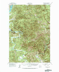
1957 Map of Euchre Mtn
USGS Topo · Published 1963About this map
Siuslaw National Forest encompasses the high ridges and steep drainages of the Oregon Coast Range in the mid-1950s, a landscape defined by the winding course of the Siletz River and Drift Creek. The river corridor is dotted with several water-access points such as Melco Landing, Mack Landing, and Morgan Landing, reflecting a period when the waterway was central to local movement and commerce. Near the Butterfield Riffle, the Reed Cr Grange stands as a focal point for the agricultural community. Higher elevations are marked by remote outposts and family-named landmarks like Minaki Place, Horner Ranch, and the Suncrest Point Lookout. These features, along with names like Camas Prairie and Elos Prairie, illustrate the complex topography where logging, ranching, and river life converged in Lincoln County.
Find a feature on this map
70 named features on this map. Tap any name to fly to it.
Don’t see what you’re looking for? This feature index may not catch every label — zoom into the map to look around manually.
Map Details
Editions of this 1957 Euchre Mtn Map
3 editions found
Other maps of this area

1939 · Marys Peak
USGS Topo · 1:62,500

1941 · Nestucca Bay
USGS Topo · 1:62,500

1941 · Cape Foulweather
USGS Topo · 1:62,500

1942 · Euchre Mtn
USGS Topo · 1:62,500

1942 · Marys Peak
USGS Topo · 1:62,500

1942 · Spirit Mtn
USGS Topo · 1:62,500

1942 · Nestucca Bay
USGS Topo · 1:62,500

1942 · Yaquina
USGS Topo · 1:62,500

1942 · Valsetz
USGS Topo · 1:62,500

1942 · Toledo
USGS Topo · 1:62,500