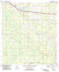
1954 Map of Eugene
USGS Topo · Published 1993About this map
Eugene serves as the primary settlement on this Dixie County landscape, situated near the headwaters of California Creek and the southern edge of Long Pond. The interior terrain is dominated by the dense, marshy expanses of California Swamp and the elevated vegetation of Old Town Hammock. This mid-century survey, based on 1950s planetable work with later 1980s aerial revisions, documents a rural environment where infrastructure like Radio Towers and the Perpetual Wildlife Management Area sit alongside established community landmarks. Researchers will find significant local genealogical interest in the presence of Prospect Ch and nearby burial grounds, specifically Long Pond Cem and Lee Cem. Further south, the landscape transitions into the isolated Davis Island, illustrating the complex drainage patterns of this coastal Florida region.
Find a feature on this map
13 named features on this map. Tap any name to fly to it.
Don’t see what you’re looking for? This feature index may not catch every label — zoom into the map to look around manually.
Map Details
Editions of this 1954 Eugene Map
3 editions found
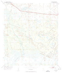
Other maps of this area

1954 · Cross City West
USGS Topo · 1:24,000

1954 · Eugene
USGS Topo · 1:24,000

1954 · Cross City East
USGS Topo · 1:24,000

1954 · Cross City SW
USGS Topo · 1:24,000

1954 · Manatee Springs
USGS Topo · 1:24,000

1954 · Vista
USGS Topo · 1:24,000

1954 · Gainesville
USGS Topo · 1:250,000

1955 · Shired Island
USGS Topo · 1:24,000

1958 · Gainesville
USGS Topo · 1:250,000

1959 · Gainesville
USGS Topo · 1:250,000