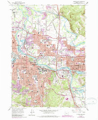
1967 Map of Eugene East
USGS Topo · Published 1967About this map
Eugene and Springfield appear in a period of significant growth, with the Willamette River and McKenzie River defining the valley floor. This mid-century survey illustrates the expansion of residential and educational infrastructure, notably centering on the University of Oregon and the newly established Autzen Stadium. The landscape is punctuated by volcanic hills such as Gillespie Butte, Skinner Butte, and Kelly Butte, which remain as green spaces amidst the encroaching urban purple-tinted zones. The river system remains complex with numerous sloughs like Patterson Slough and Dodsons Slough weaving through the floodplain. Transport networks are dominated by the Southern Pacific and Burlington Northern railroads, alongside the maturing Pacific Highway, reflecting the region's importance as a Pacific Northwest transit and education hub.
Find a feature on this map
69 named features on this map. Tap any name to fly to it.
Don’t see what you’re looking for? This feature index may not catch every label — zoom into the map to look around manually.
Map Details
Editions of this 1967 Eugene East Map
3 editions found
Other maps of this area

1910 · Eugene
USGS Topo · 1:62,500

1921 · Cottage Grove
USGS Topo · 1:62,500

1935 · Lowell
USGS Topo · 1:96,000

1940 · Eugene
USGS Topo · 1:62,500

1942 · Lowell
USGS Topo · 1:125,000

1946 · Eugene
USGS Topo · 1:62,500

1949 · Eugene
USGS Topo · 1:62,500

1950 · Marcola
USGS Topo · 1:62,500

1952 · Marcola
USGS Topo · 1:62,500

1953 · Salem
USGS Topo · 1:250,000