
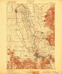
1910 Map of Eugene
USGS Topo · Published 1910About this map
The Willamette River defines the central valley corridor of this 1910 survey, showing a highly braided river system punctuated by landforms like Good Pasture Island and Marshall Island. In the southern portion, the growing city of Eugene is anchored by Skinner Butte and the early campus of the University of Oregon. The surrounding landscape is a dense network of early rural education, with dozens of family-named institutions such as Santa Clara School, Deadman School, and Harpole School serving the farming communities between the main settlements of Junction City and Springfield.
Find a feature on this map
53 named features on this map. Tap any name to fly to it.
Don’t see what you’re looking for? This feature index may not catch every label — zoom into the map to look around manually.
Map Details
Editions of this 1910 Eugene Map
2 editions found
Other maps of this area

1909 · Harrisburg
USGS Topo · 1:31,680

1909 · Rowland
USGS Topo · 1:31,680

1909 · Elmira
USGS Topo · 1:62,500

1911 · Monroe
USGS Topo · 1:31,680

1912 · Halsey
USGS Topo · 1:62,500

1921 · Brownsville
USGS Topo · 1:62,500

1921 · Cottage Grove
USGS Topo · 1:62,500

1922 · Monroe
USGS Topo · 1:62,500

1922 · Elmira
USGS Topo · 1:62,500

1935 · Lowell
USGS Topo · 1:96,000