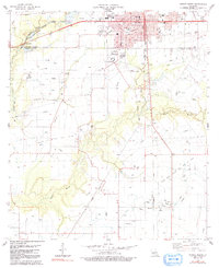
1983 Map of Eunice South
USGS Topo · Published 1991About this map
The northern edge of Acadia Parish meets the outskirts of Eunice in this 1983 study, where the prairie landscape is defined by the convergence of agricultural drainage and industrial expansion. The southern expansion of the city is marked by civic and educational institutions like St Edmonds High Sch and the Voc Tech Sch, while the outlying lands show a heavy reliance on the energy sector. The map details the extensive Riche and Gas Field and the North Tepetate Oil and Gas Field, indicating the economic engine of the era. Smaller settlements such as Mowata and Frey are anchored by local landmarks like St Lawrence Ch and Mowata Cem. Waterways like Bayou Mallet and South Bayou Mallet weave through the township sections, intersected by the Missouri Pacific railroad, illustrating the transport network essential for both rural farming and the local oil industry.
Find a feature on this map
30 named features on this map. Tap any name to fly to it.
Don’t see what you’re looking for? This feature index may not catch every label — zoom into the map to look around manually.
Map Details
Editions of this 1983 Eunice South Map
2 editions found
Other maps of this area

1935 · Branch
USGS Topo · 1:31,680

1947 · Evangeline
USGS Topo · 1:31,680

1947 · Fruge Lake
USGS Topo · 1:31,680

1947 · Branch
USGS Topo · 1:31,680

1947 · Redland
USGS Topo · 1:31,680

1947 · Chataignier
USGS Topo · 1:31,680

1947 · Eunice
USGS Topo · 1:31,680

1947 · Iota
USGS Topo · 1:31,680

1947 · Pitreville
USGS Topo · 1:31,680

1947 · Basile
USGS Topo · 1:31,680