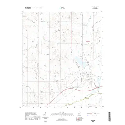
2018 Map of Eupora
USGS Topo · Published 2018About this map
Eupora serves as the focal point of this region in Webster County, sitting north of the winding Big Black River Canal. The landscape is defined by the convergence of several waterways, including Little Sand Creek and Hays Creek, which navigate around the modest elevations of Sand Mountain and Rocky Mountain. This 2018 survey reveals a territory dense with family and community history, evidenced by a high concentration of small burial grounds such as South Union Cemetery and Jordons Cemetery. To the north, the small settlement of Walthall sits along County Road 50, while the southern reaches near Grady show the interaction between modern infrastructure like the Eupora Airport and the historical boundary of the Big Black River, which forms the line between Webster and Choctaw counties.
Find a feature on this map
98 named features on this map. Tap any name to fly to it.
Don’t see what you’re looking for? This feature index may not catch every label — zoom into the map to look around manually.
Map Details
Editions of this 2018 Eupora Map
This is the sole edition of this map. No revisions or reprints were ever made.
Other maps of this area

1953 · Walthall
USGS Topo · 1:62,500

1953 · West Point
USGS Topo · 1:250,000

1958 · West Point
USGS Topo · 1:250,000

1963 · West Point
USGS Topo · 1:250,000

1966 · Stewart
USGS Topo · 1:24,000

1966 · Tomnolen
USGS Topo · 1:24,000

1968 · Weir
USGS Topo · 1:62,500

1972 · Sapa
USGS Topo · 1:24,000

1972 · Hohenlinden
USGS Topo · 1:24,000
1972 · Reform
USGS Topo · 1:24,000