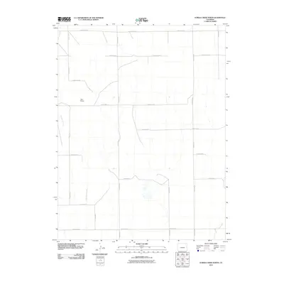
2010 Map of Eureka Creek North
USGS Topo · Published 2010About this map
Twin Buttes rises as a prominent topographical landmark in this open stretch of Cheyenne County, where the high plains landscape is defined by a rigid section-line road grid. The drainage of Little Spring Creek meanders through the western half of the terrain, providing a rare break in the geometric regularity of the county's infrastructure. This 2010 survey illustrates the deep-rooted reliance on a systematic transportation network, with major corridors such as County Rd DD, County Rd 25, and County Rd 28 facilitating movement across the expansive agricultural or ranching plots. The sparse distribution of named natural features versus the dense network of numbered and lettered routes, such as County Rd AA and County Rd V, highlights the organized human imprint on this Colorado landscape during the early 21st century.
Find a feature on this map
17 named features on this map. Tap any name to fly to it.
Don’t see what you’re looking for? This feature index may not catch every label — zoom into the map to look around manually.
Map Details
Editions of this 2010 Eureka Creek North Map
This is the sole edition of this map. No revisions or reprints were ever made.
Other maps of this area

1891 · Kit Carson
USGS Topo · 1:125,000

1893 · Kit Carson
USGS Topo · 1:125,000

1954 · Limon
USGS Topo · 1:250,000

1954 · Lamar
USGS Topo · 1:250,000

1957 · Limon
USGS Topo · 1:250,000

1958 · Limon
USGS Topo · 1:250,000

1958 · Lamar
USGS Topo · 1:250,000

1969 · Alpine Ranch
USGS Topo · 1:24,000

1979 · Stratton 3 SE
USGS Topo · 1:24,000
1979 · Alpine Ranch SW
USGS Topo · 1:24,000