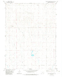
1982 Map of Eureka Creek North
USGS Topo · Published 1982About this map
Twin Buttes rises as a prominent landmark in this high plains landscape of Cheyenne County, surveyed in the mid-1970s and published in the early 1980s. The terrain is defined by the drainage patterns of Eureka Creek and Little Spring Creek, which cut through the open rangeland. Human activity in this arid environment is clearly marked by the presence of numerous Tank sites and a Well, indicating the critical importance of water management for cattle ranching or local industry. This survey captures the rural character of the eastern Colorado plains before contemporary developments, showcasing the section lines and township boundaries of T 12 S and T 13 S that structured early settlement and land ownership in the region.
Find a feature on this map
7 named features on this map. Tap any name to fly to it.
Don’t see what you’re looking for? This feature index may not catch every label — zoom into the map to look around manually.
Map Details
Editions of this 1982 Eureka Creek North Map
This is the sole edition of this map. No revisions or reprints were ever made.
Other maps of this area

1891 · Kit Carson
USGS Topo · 1:125,000

1893 · Kit Carson
USGS Topo · 1:125,000

1954 · Limon
USGS Topo · 1:250,000

1954 · Lamar
USGS Topo · 1:250,000

1957 · Limon
USGS Topo · 1:250,000

1958 · Limon
USGS Topo · 1:250,000

1958 · Lamar
USGS Topo · 1:250,000

1969 · Alpine Ranch
USGS Topo · 1:24,000

1979 · Stratton 3 SE
USGS Topo · 1:24,000
1979 · Alpine Ranch SW
USGS Topo · 1:24,000