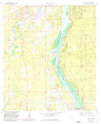
1970 Map of Eureka Dam
USGS Topo · Published 1982About this map
The Oklawaha River corridor dominates this landscape, showing the area as it transitioned following the construction of the Eureka Dam. This 1970s era documentation captures a river system transformed into Lake Oklawaha, a reflection of large-scale water management projects of the mid-20th century. To the east, the Ocala National Forest Wildlife Management Area provides a wilderness contrast to the settled pockets near Hog Valley and the village of Eureka.
Find a feature on this map
25 named features on this map. Tap any name to fly to it.
Don’t see what you’re looking for? This feature index may not catch every label — zoom into the map to look around manually.
Map Details
Editions of this 1970 Eureka Dam Map
3 editions found
Other maps of this area

1893 · Citra
USGS Topo · 1:62,500

1895 · Citra
USGS Topo · 1:62,500

1915 · Interlachen
USGS Topo · 1:48,000

1916 · Interlachen
USGS Topo · 1:62,500

1938 · Hawthorn
USGS Topo · 1:48,000

1943 · Hawthorn
USGS Topo · 1:62,500

1944 · Interlachen
USGS Topo · 1:62,500

1949 · Keuka
USGS Topo · 1:24,000

1949 · Rodman
USGS Topo · 1:24,000

1949 · Interlachen
USGS Topo · 1:62,500