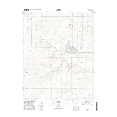
2015 Map of Eureka
USGS Topo · Published 2015About this map
Eureka sits at the heart of this landscape, its grid of streets such as W 10th St and E River St organized north of a prominent bend in the Fall River. This mid-2010s survey captures the seat of Greenwood County as a hub for the surrounding plains, where the town's eastern edge is marked by the sprawling grounds of Greenwood Cem. The geography is defined by a dendritic network of waterways, including Bachelor Cr to the northeast and the meandering Spring Creek to the southwest, which drain the undulating terrain. To the north of the main settlement, the Lt. William M. Milliken Airport serves as a modern waypoint. The map clearly delineates the township and range system, showing the transition between t25s r9e and t25s r10e, revealing a rural infrastructure of named section roads like Twp Rd 334 and 180th St that connect isolated farmsteads to the commercial center of Eureka.
Find a feature on this map
71 named features on this map. Tap any name to fly to it.
Don’t see what you’re looking for? This feature index may not catch every label — zoom into the map to look around manually.
Map Details
Editions of this 2015 Eureka Map
This is the sole edition of this map. No revisions or reprints were ever made.
Other maps of this area

1885 · Eureka
USGS Topo · 1:125,000

1888 · Eureka
USGS Topo · 1:125,000

1894 · Eureka
USGS Topo · 1:125,000

1939 · Severy
USGS Topo · 1:62,500

1941 · Severy
USGS Topo · 1:62,500

1955 · Wichita
USGS Topo · 1:250,000

1958 · Wichita
USGS Topo · 1:250,000

1964 · Piedmont NW
USGS Topo · 1:24,000
1964 · Piedmont NE
USGS Topo · 1:24,000
1971 · Eureka
USGS Topo · 1:24,000