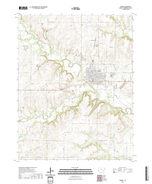
2022 Map of Eureka
USGS Topo · Published 2022About this map
The Eureka townsite serves as the central hub of this Greenwood County landscape, where the confluence of the West Branch Fall River and East Branch Fall River forms the main Fall River. The town's grid is anchored by the Greenwood County Courthouse and extends toward the northern reaches of the Lt William M Milliken Airport. Beyond the urban center, the geography is defined by a dendritic drainage pattern of small creeks like Bachelor Cr and Kitty Cr, alongside several family and local-history landmarks such as Greenwood Cem. The extensive network of township roads, including 150th St and 180th St, illustrates the persistent section-line development characteristic of the Kansas prairie. This survey details the transition from the structured residential blocks of the county seat to the sprawling agricultural tracts and waterways that drive the region's rural economy.
Find a feature on this map
90 named features on this map. Tap any name to fly to it.
Don’t see what you’re looking for? This feature index may not catch every label — zoom into the map to look around manually.
Map Details
Editions of this 2022 Eureka Map
This is the sole edition of this map. No revisions or reprints were ever made.
Other maps of this area

1885 · Eureka
USGS Topo · 1:125,000

1888 · Eureka
USGS Topo · 1:125,000

1894 · Eureka
USGS Topo · 1:125,000

1939 · Severy
USGS Topo · 1:62,500

1941 · Severy
USGS Topo · 1:62,500

1955 · Wichita
USGS Topo · 1:250,000

1958 · Wichita
USGS Topo · 1:250,000

1964 · Piedmont NW
USGS Topo · 1:24,000
1964 · Piedmont NE
USGS Topo · 1:24,000
1971 · Eureka
USGS Topo · 1:24,000